|
|
The majority of the text that follows has been pulled from various sources on the Internet that I found myself. I hope it can help you plan your trip to this fabulous place. ENJOY! |
|
|
|
|
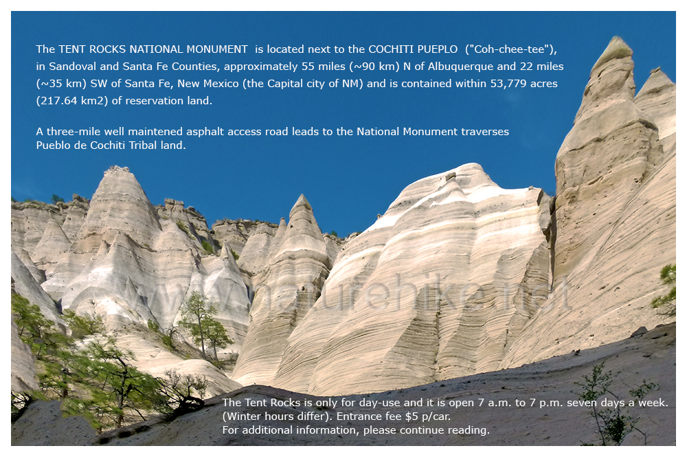
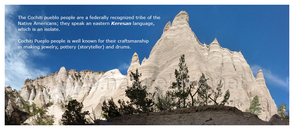
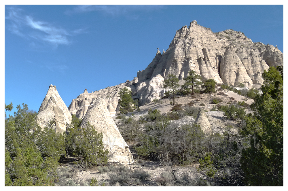
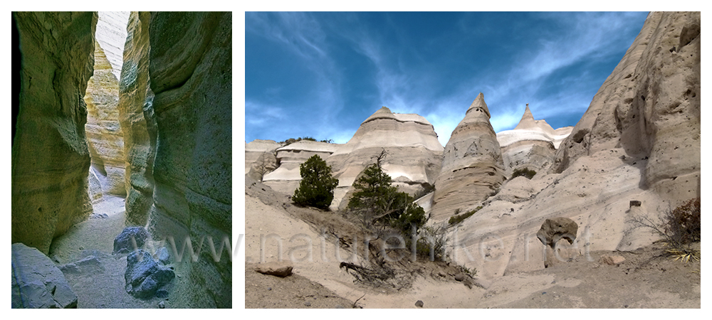
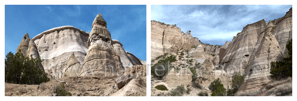
At TENT ROCKS (Kasha-Katuwe) , the cone-shaped tent rock formations are the products of volcanic eruptions that occurred 6-7 million years ago and left pumice, ash, and tuff deposits over 1,000 feet thick. This whole area is a remarkable outdoor laboratory and is also similar to CAPPADOCIA (*), which is in my native country of Turkey, and is known as GOREME... offering to observe, study and experience the geologic processes that shaped natural landscapes. In both areas, land was shaped as a result of volcanic eruptions that occurred millions of years ago. While you may plan a visit to CAPPADOCIA, it is also a truly worthwhile journey visiting TENT ROCKS here stateside. The biggest difference between TENT ROCKS and CAPPADOCIA is that there were habitants in Cappadocia (Hatties, Luvies and Hittites, during 3000-2000 years B.C. No known inhabitants were known to have resided at any time in history in Tent Rocks. Although TENT ROCKS can be compared in some ways to CAPPADOCIA. CAPPADOCIA covers more land area. It is within the CAPPADOCIA CAVES that Christians hid within the CAPPADOCIA dwellings as Christians were being persecuted by the Roman empire for their beliefs during that time. 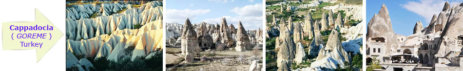 (*) There is no city or town officially called CAPPADOCIA in Turkey, BUT this ancient name is commonly used and recognized by tourists. CAPPADOCIA is located at the edge of two central Anatolian cities: GOREME and URGUP areas. Turks call this area GOREME or URGUP PERI BACALARI (fairy chimneys of Urgup) in Turkish. Furthermore, in this area there are a series of magnificent underground cities, cave churches, and houses carved into the rocks of Cappadocia. For more information on CAPPODOCIA, which is one of the most important tourism centers of Turkey, visit my website www.helloturkey.net/cappadocia.html |
|
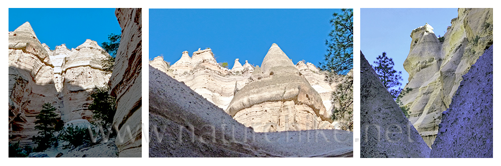
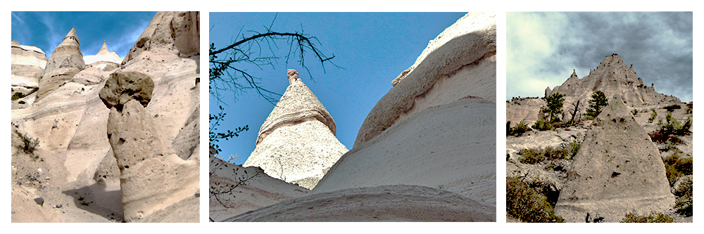
The cone-shaped rock formations were formed as wind and water eroded pumice and tuff deposits. Their hard, erosion-resistant cap rocks protect the softer tents below. While uniform in shape, the tent rock formations vary in height from a few feet to 90 feet high. |
|
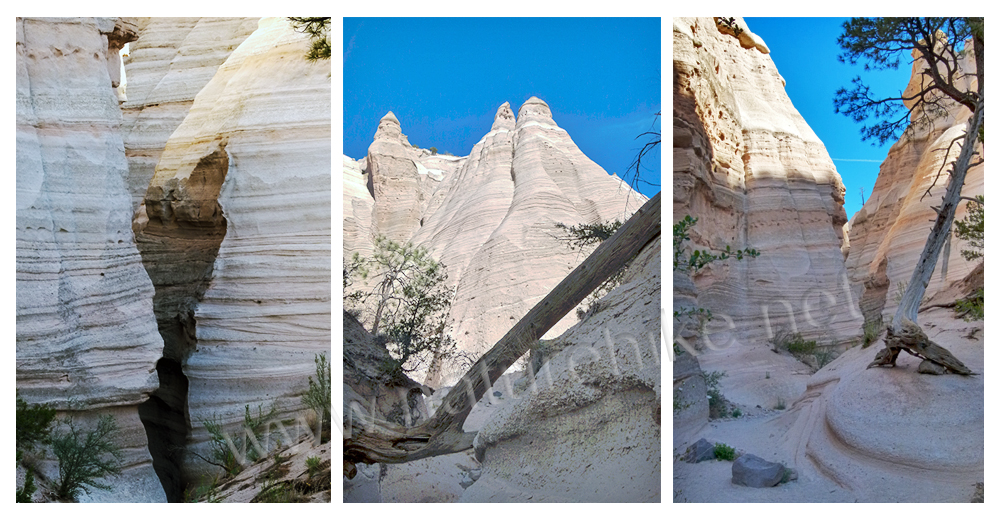
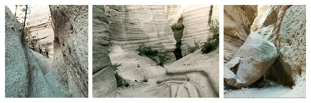
The hike through the canyon varies from easy to moderate but sometimes the canyon gets very narrow and you'll have to duck under some overhanging rocks and climb high steps. The elderly and/or families with small children might find it difficult to navigate. Also the ground is soft and steep; using a hiking stick/walking stick is recommended. |
|
|
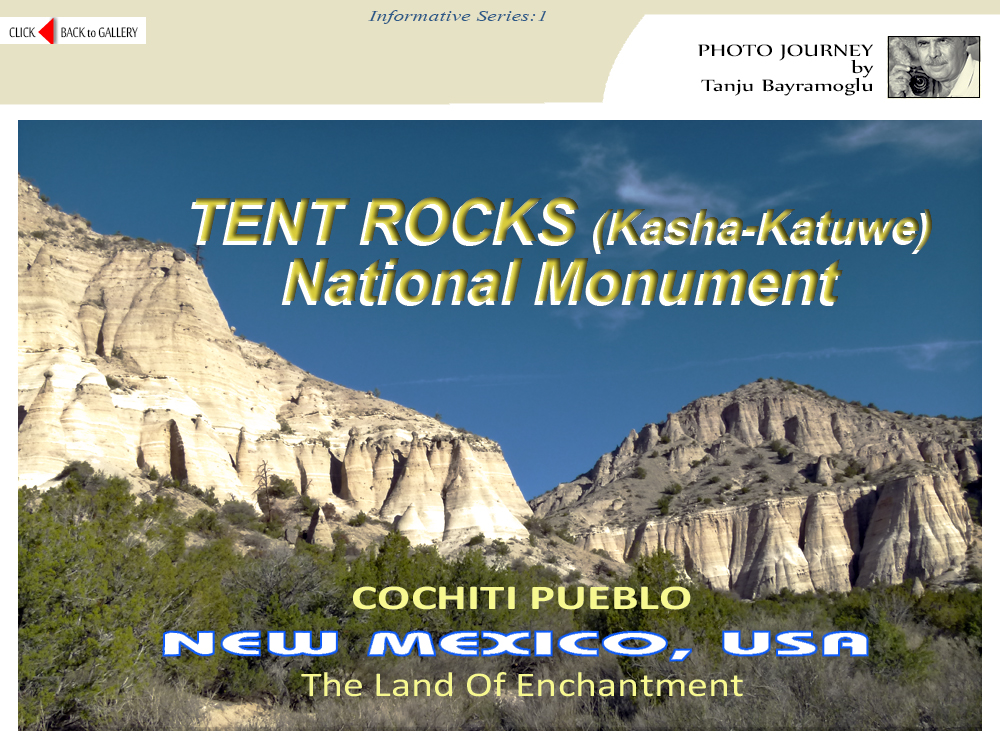
The COCHITI PUEBLO TRIBE has always considered this area a significant place. 'Kasha-Katuwe' means white cliffs in the traditional Keresan language of the pueblo. Under the BLM's administration, these lands were designated as an Area of Critical Environmental Concern. This land contains the Tent Rocks Trail, which was established as a U.S. National Monument by President Bill Clinton in January 17, 2001 shortly before leaving office. |
|
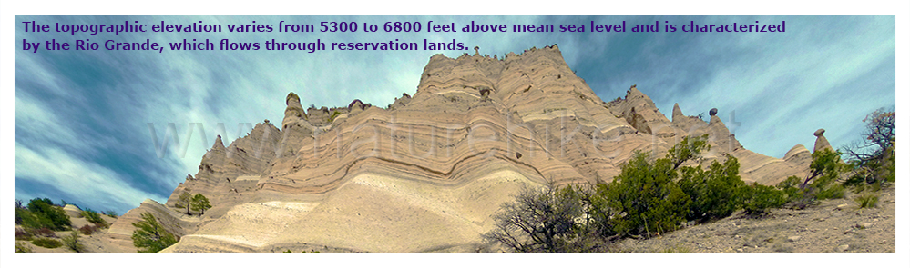
There are two recreational trails for foot travel only: The Cave Loop Trail and Canyon Trail. Trails begin at the designated parking area which is very well designed and maintained. The Cave Loop Trail is 1.2 miles (~2 km) long, and rated as easy. The more difficult Canyon Trail is a 1.5 mile (~2.5 km), one-way trek into a narrow canyon with a steep 630 foot climb to the mesa top for excellent views of the De Cristo, Jemez, Sandia mountains and the Rio Grande Valley. Because of a big rock blockage on a portion of the trial, and at my age, I couldn't complete the hike to the top but I can say that I made it 2/3's of the way. Again, this trail is not a loop. On a personal note, Canyon Trail was my favorite area. |
|
For those who have not yet to venture to TENT ROCKS (Kasha Katuwe), I highly recommend it. I visited the area in mid-May and enjoyed the weather but the hike can be quite hot during summer. During the winter, snow falls in this area, which can make it difficult for hiking. Lastly, I heard that the unique terrain has attracted several movie makers; such as Lonesome Dove, Young Guns II, and Silverado are among the films with scenes shot here. |
|
I M P O R T A N T : Please be advised that TENT ROCKS is only for day-use, you can experience it as just a great day-hike or you can camp nearby at COCHITI LAKE campground, then drive the few miles to TENT ROCKS. Please note that TENT ROCKS is closed to dogs. Dogs are not even allowed to be left in a vehicle. There are no kennels either so you must leave your dog at home. Specific rules are in place at TENT ROCKS including no alcohol and use of mountain bikes. Where the trials begin, there is a well designated parking area which is well maintained. Honestly I can say that this area is one of the best arranged/managed trial entrance areas that I have seen. In addition, there are shaded picnic tables and clean toilets. Although the facilities are well maintained, please note that there is no running water available at TENT ROCKS. You must bring your own water. The elderly, disabled, and families with small children should not hike at TENT ROCKS due to the difficultly in managing the terrain. Besides the picnic area at the entrance, I only saw one bench half way along the Canyon trail. Other than this one bench, there is no place for sitting! Park officials advise to remain on the trails at all times as the surrounding terrain is soft and uneven. I was disappointed that I did not see any birds during my visit in May. I am an avid bird watcher / photographer & did not see even one bird during my visit. Although it might have been due to the time of year I visited. |
|
|
The Canyon trail, especially as you climb, gets very narrow and you'll have to duck under some overhanging rocks and step over large rocks. The picture show above/right shows where I had to stop my hike on the Canyon trail. Given my belly, I couldn't go any more :) and thereby was unable to experience the views from the mesa top of Sangre de Cristo, Jemez, Sandia mountains and the Rio Grande Valley, etc. As for my next visit, I'll be better prepared for the hike & will not be going alone. H O W T O G E T T H E R E : From Albuquerque take I-25 north and take the exit for Santo Domingo/Cochiti Lake Recreation Area (Exit 259) NM-22 OR a little bit later on off I-25 onto NM-16. Anyway these NM-22 and NM-16 gets together in point then follow on NM-22 and sign will help you going to Cochiti Pueblo and Tent Rocks National Monument (Kasha-Katuwe). From Santa Fe take I-25 south to the turn off to NM-16 to Cochiti Pueblo and Cochiti Lake. It was my pleasure to have you on this website. I hope you enjoyed seeing my pictures and all the explanations can be helpful for you before you'll be visiting this wonderful place. NOTE: When you'll visit Rock Tents at Cochiti Pueblo consider visiting other American Indian(Natives') which are spreaded across north central, central, and northwest New Mexico. They are pretty close each other and each pueblo is unique, with their own distinct artistic styles, attractions, and customs... Thank you for visiting this website; it has been a pleasure to have you visit. I hope you enjoyed viewing my pictures and hope that my explanation and experiences on this area can be helpful for you in planning your trip to TENT ROCKS NATIONAL MONUMENT. |
|
|
|
All Rights Reserved. © 2008-2025 NATUREHIKE.NET. This site was created by Tanju Bayramoglu and launched in 2008 and updated on March 2025. Powered from Phoenix,USA. The majority of the text used in this presentation has been taken from various sources on the Internet. All images appearing in this site are the exclusive property of www.NATUREHIKE.net and in any form may not be reproduced, copied, stored, or manipulated without the written permission of Tanju Bayramoglu. |